LOS ANGELES · EST. 1932 Friday, November 20, 2026 · Pacific editionNewsroom
NUNTIA LIBERA
PER MUNDOS ET SAECULA
Los Angeles

Checking the weather…

Change locationLos Angeles

YOUR EDITION / ONE LOCATION

Make yourself at home

One choice sets your weather, local reporting and regional defaults across the Herald. You can refine each section afterward.

Use your approximate location for local news and weather?

Only Yes sends your IP address to IPWhois to find an approximate city. No keeps Los Angeles.

Search worldwide by city, state or country.

    Selected: Los Angeles.

    City search: Open-Meteo · GeoNames · CC BY 4.0

    MET NorwayCC BY 4.0

    The Aeon Herald / HISTORICAL EDITION

    A Broken Freeway Span Makes the Earthquake’s Force Visible

    A FEMA photograph records a collapsed interchange; its visible damage is evidence of an event, not a complete engineering explanation.
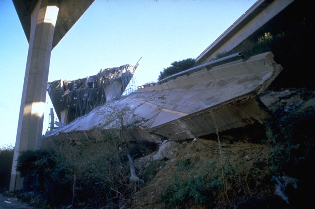
    A fallen concrete freeway span with exposed reinforcing steel after the January 1994 Northridge earthquake.
    IMAGE / FEMA News Photo
    Collapsed freeway interchange following the Northridge earthquake, January 17, 1994. Photograph: FEMA News Photo. Public domain in the United States; reproduced without alteration. The photograph records one location, not the full extent of damage. Image source · Reuse basis.
    Unlocked by patron

    LOS ANGELES, Feb. 10 — In a FEMA photograph made after the January 17 Northridge earthquake, a fallen length of freeway cuts diagonally through the frame. Reinforcing steel projects from broken concrete; a standing elevated roadway crosses above it.

    The picture records the interruption of a structure built to carry movement. Its strongest visual fact is the separation between the roadway’s intended line and the mass of concrete now resting below that line.

    It is also a limited record. The camera shows the condition of this interchange after the shaking, not the sequence of forces that produced the failure. The visible steel and fractured surfaces cannot, by themselves, establish a particular design defect or assign responsibility.

    USGS strong-motion records provide another kind of evidence. Instruments throughout the region captured the earthquake’s acceleration; the agency’s early report describes readings approaching or exceeding gravity at some sites. Those measurements can be compared with structures and locations in a way that a single photograph cannot supply.

    The photograph is dated January 17 and credited to FEMA News Photo.

    Sources & further reading
    Related Herald reporting

    THE READING ROOM

    Discussion

    Conversations are reviewed by the newsroom before they appear. Your display name and approved comment are public.

    No published comments yet.

    Join the conversation

    No email address is requested. Please keep private information out of your comment.

    Choose what this browser remembers, whether analytics may load and which external widgets can load. Necessary sign-in and security cookies are controlled by your browser.

    Analytics is optional and off until allowed. Disabling analytics stops future loading and clears accessible analytics cookies. Disabling a preference clears its local data. Learning remains a separate opt-in in Your Interests. Disabling external widgets stops future loading; remove existing provider cookies through your browser.

    Read the Cookie Policy